UAV Update - A Look Inside the Mohajer-4's GCS
This past August, the governor of Ilam met with a team from the Artesh to examine whether or not UAVs could be used to help fight the wildfires blazing across the mountainous province in western Iran. As part of this process, the team conducted a demonstration flight.
This event was captured by photographers from IRNA who have published some of the most comprehensive images of the system's support equipment seen thusfar.
The full gallery is available here.
The article describing the evaluation is available here.
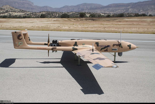
 The UAV in question was a recent-generation Mohajer-4, which can be distinguished from earlier examples by its streamlined fuselage. It is likely operated by the Army's Ground Forces, though the Air Force is a plausible alternative. One crew-member wore an unrecognizable patch on the front of his jumpsuit.
This example bears the serial "P062A-36". This is consistent with the only other documented serial of this type - P062A-007 - which was found on an airframe downed by ISIS over eastern Syria in January 2015. Both of these are also consistent with the pattern among other M4s, where the first string of text identifies the model (A041 on previous-generation M4s) and the second string identifies the unique air-frame. This suggests there are at least 36 new-generation airframes.
The setup is operated by a crew of between five and seven. This includes two operators, a mission commander, and a launch section. System components include a towed launch rail for rocket-assisted-takeoff, a flatbed truck, a crane truck, a light van, a generator, and a containerized GCS. It is expected that a transport/storage/maintenance container is also part of a typical deployment, though it was absent in this photo-set.

Part of the photo-set's value is the high quality shots of the interior GCS and its operator controls. Three consoles line the container, facing the cab. The payload operator sits to the right, controlling the camera and the directional tracking antenna fitted to the roof used for real time media transfer. The center console displays flight control software used for automatic route planning. The software used here is a US-made COTS product named "FliteMap" marketed to civilian aviators. The left console displays engine information and other telemetry data.


This event was captured by photographers from IRNA who have published some of the most comprehensive images of the system's support equipment seen thusfar.
The full gallery is available here.
The article describing the evaluation is available here.
 The UAV in question was a recent-generation Mohajer-4, which can be distinguished from earlier examples by its streamlined fuselage. It is likely operated by the Army's Ground Forces, though the Air Force is a plausible alternative. One crew-member wore an unrecognizable patch on the front of his jumpsuit.
This example bears the serial "P062A-36". This is consistent with the only other documented serial of this type - P062A-007 - which was found on an airframe downed by ISIS over eastern Syria in January 2015. Both of these are also consistent with the pattern among other M4s, where the first string of text identifies the model (A041 on previous-generation M4s) and the second string identifies the unique air-frame. This suggests there are at least 36 new-generation airframes.
The setup is operated by a crew of between five and seven. This includes two operators, a mission commander, and a launch section. System components include a towed launch rail for rocket-assisted-takeoff, a flatbed truck, a crane truck, a light van, a generator, and a containerized GCS. It is expected that a transport/storage/maintenance container is also part of a typical deployment, though it was absent in this photo-set.

Part of the photo-set's value is the high quality shots of the interior GCS and its operator controls. Three consoles line the container, facing the cab. The payload operator sits to the right, controlling the camera and the directional tracking antenna fitted to the roof used for real time media transfer. The center console displays flight control software used for automatic route planning. The software used here is a US-made COTS product named "FliteMap" marketed to civilian aviators. The left console displays engine information and other telemetry data.


Comments
Post a Comment