Other Projects I've been Working on ...
This past quarter, as I wound up my time as an undergraduate, I took a class on the use of geospatial-information-systems, giving me a chance to play around with something other than Google Earth for a change. As one would imagine, I turned my efforts toward Iran, producing a handful of maps relating to the interdiction of petrochemicals in the Persian Gulf.
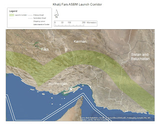
The first map shows the potential launch zone for the Khalij Fars ASBM. Since the Khalij Fars is based on the Fateh-110, it's reasonable to assume that it has a similar minimum range. This means that in order to fire upon ships traveling through the strait, the TELs have to be located within a relatively narrow corridor.
In creating the map, I took the range claim of 300 km at face value, which represents an increase of 50 km over the published range of the Fateh-110. While the official minimum range is unknown, for the sake of this experiment, I added 50 km to the minimum range of the Fateh-110.


The third and final map shows the operational profile of IRGCN HSPBs. The assumed speed is derived from an average of official specifications from MODLEX, and from official statements.

The first map shows the potential launch zone for the Khalij Fars ASBM. Since the Khalij Fars is based on the Fateh-110, it's reasonable to assume that it has a similar minimum range. This means that in order to fire upon ships traveling through the strait, the TELs have to be located within a relatively narrow corridor.
In creating the map, I took the range claim of 300 km at face value, which represents an increase of 50 km over the published range of the Fateh-110. While the official minimum range is unknown, for the sake of this experiment, I added 50 km to the minimum range of the Fateh-110.

The second series of maps illustrates the operational profile of select ASCMs launched from the coast, and a selection of fortified Islands from within the Gulf.


The third and final map shows the operational profile of IRGCN HSPBs. The assumed speed is derived from an average of official specifications from MODLEX, and from official statements.


Comments
Post a Comment